Showing posts with label Broward County. Show all posts

Wednesday, October 13, 2010

Report Card: Fort Lauderdale / Lauderdale Lakes, Broward County, Florida

Fort Lauderdale / Lauderdale Lakes
Broward County, Florida
Dr. Martin Luther King Jr Avenue
(Also known as: NW 31st Avenue)
Zip Codes: 33312 / 33311 / 33309 (south to north)

Overview: If you click on the map below you will not see an MLK Blvd (or in this case, MLK Avenue) anywhere in sight. For reasons still unknown to me (but which I will be investigating), Google Maps still does not show NW 31st Avenue as Dr. Martin Luther King Jr Avenue. Neither did Mapquest. Regardless, the street signs all show both MLK Avenue and NW 31st Avenue for the duration of the road that I traveled. The Broward Transit Route Map did show Route 40 going along the northern length of what it referred to as MLK Blvd. (not Avenue...go figure), which it also showed turning into NW 31st Street when it passed Commercial Boulevard in the north.

MLK Avenue through Fort Lauderdale starts in a thriving residential community of single-family homes south of Davie Boulevard in South Fort Lauderdale. (See photo of home below.) Heading north, the parcels of land along MLK Ave. start becoming commercialized while the residential neighborhoods continue behind the commercial buildings.
At NW 19th Street you enter Lauderdale Lakes, and by the time you reach Oakland Park Boulevard (the equivalent of 31st Street) the area is heavily commercial and even borders on becoming industrial. It gradually transitions back to residential, and by the time you reach NW 40th Street the street signs no longer reference NW 31st Avenue as MLK Avenue.

Length: Approximately 5 miles
From 1300 Block South to 3900 Block North.
(Davie Boulevard in the south to just shy of Commercial Boulevard in the north)

Classifications:
Residential Neighborhood (houses and apartments visible to MLK Avenue) = 50%
Vacant = 15%
Blighted and Ignored = 5%
Blighted but Not Ignored = 5%
Gentrification Failing = 0
Gentrification Succeeding = 0
Viable with Room to Improve = 50%
Vibrant and Car Friendly = 25%
Vibrant and Pedestrian Friendly = 0
Commercial Corridor: Main Street = 10%
(Only at the crossroads with east/west major intersections.)
Gentrification Failing = 30%
Gentrification Succeeding = 10%
Viable with Room to Improve = 60%
Commercial Corridor: Mom & Pop Shops = 20%
Vacant = 50%
Blighted and Ignored = 10%
Blighted but Not Ignored = 20%
Gentrification Failing = 10%
Gentrification Succeeding = 0
Viable with Room to Improve = 10%
Vibrant and Car Friendly = 0
Vibrant and Pedestrian Friendly = 0
Industrial Corridor = 15%
Vacant = 30%
Blighted and Ignored = 30%
Blighted but Not Ignored = 40%
Gentrification Failing = 0
Gentrification Succeeding = 0
Viable with Room to Improve = 0
Vibrant = 0
Institutional and Parks = 5%
Gentrification Succeeding = 50%
Viable with Room to Improve = 50%
Community Assets:
Parks and Community Centers: There are several schools along the length of this MLK Avenue, owing primarily to how heavily residential the corridor is. Most of the schools did not front MLK Avenue but the number of school zones were evidence that they were there, just out of sight. On the property with the Dr. Martin Luther King Jr Elementary School there was a school with the name "Title I Migrant and Special Programs" on the sign out front. The one visible community center that fronts on MLK Avenue, the brand new Edgar P. Mills Multi-Purpose Center, was tough to research on the web, but I believe it to be a "Family Success Center" and arts facility. It was disturbing to see that almost without exception, Broward.org cited the address as 900 NW 31 Ave. and made no reference to the fact that it was on MLK Avenue. This bears some more investigation as to why that would be.

Churches: There were less than a dozen churches that fronted on this MLK Avenue. I imagine that the small number has to do with how accessible the area is to other more suitable church sites, such as the very successful (and large) Black churches in the nearby historically Black Sistrunk neighborhood. On the map you will see several churches along the east-west corridors, just a few blocks off MLK Avenue.

National Chain Grocery or Department Stores: None were encountered, not even at the junctions with the major east-west corridors.

Brand Name Franchised Restaurants: A few (your typical KFC and Church's Chicken) were visible from MLK Avenue when I crossed Broward Boulevard, Sunrise Boulevard and Oakland Park Boulevard.

Other National Franchises: Familiar auto parts franchise stores were visible only at the east-west crossroads noted above.
NIMBY Items Encountered:
There is a massive flood reservoir to the east of MLK Avenue between NW 13th and 17th Streets, but it was sheltered by a dike and not visible from the street. The four blocks of chain link fencing were not too attractive though, and gave the appearance of more vacant land.

There were no rail corridors crossing this MLK Avenue because it ran parallel to the CSX Railway corridor ten blocks to the east.

There were two highly visible major power substations along this MLK Avenue.
Indexing for This Topic

Friday, September 24, 2010

Report Card: MLK Blvd, Pompano Beach, Florida

Pompano Beach

Broward County, Florida

Dr. Martin Luther King Jr Boulevard

(formerly named: Hammondville Road and Third Street)

Zip Code: 33060

Overview:

MLK Blvd through Pompano Beach starts at Dixie Highway, which is the historical center of the city that divides east from west at the railway tracks. Heading west, it is a four-lane road with commercial zoning fronting the road. To the south is the commercial core of Pompano Beach, and immediately behind the commercial zoning to the north is a viable but hurting residential neighborhood. The locals, including the Black locals, still refer to this section of MLK Blvd as Third Street.

After about a mile one drives under the I-95 freeway (no entrance to freeway) and enters the industrial corridor. This section of MLK Blvd is still referred to by the locals as Hammondville Road. On both sides of the freeway the area has a hard-core inner-city feel to it and I would not be anywhere near here after dark. From here (the 1100 block) to the end, the area to the north is pure industrial, with the exception of the Sunshine Health Center at 1711 MLK Blvd. This is a health center that caters to Medicaid and Medicare recipients and also offers dentistry. The area to the south is residential, and a sheriff’s substation is located on the corner of 18th Avenue.
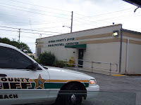
Once past Powerline Road (2100 block), you are in NIMBY land, where there are two strip joints and three prisons within blocks of MLK Blvd.

MLK Blvd ends at NW 31 Avenue, where there is a Florida Turnpike entrance.

Length:

Approximately 3 miles

·000 Block (Dixie Highway) to 3100 Block West.

Category:

Residential Neighborhood (houses fronting MLK Blvd) = 0%

Commercial Corridor: Main Street = 0%

Commercial Corridor: Mom & Pop Shops = 20%

·Blighted and Ignored = 30%

·Blighted but Not Ignored = 30%

·Gentrification Failing = 0%

·Gentrification Succeeding = 10%

·Viable with Room to Improve = 20%

·Vibrant and Car Friendly = 10%

· Vibrant and Pedestrian Friendly = 0%

Industrial Corridor = 80%

·Blighted and Ignored = 50%

·Blighted but Not Ignored = 30%

· Gentrification Failing = 0%

·Gentrification Succeeding = 10%

·Viable with Room to Improve = 10%

· Vibrant and Car Friendly = 0%

·Vibrant and Pedestrian Friendly = 0%

Community Assets:

1) The E. Pat Larkins Community Center at 520 MLK Blvd. It is a brand new facility built in a relatively safe area. It seemed well staffed with a broad variety of programs for all age groups. (http://www.mypompanobeach.org)

2)Churches: Along the length of the boulevard there were three significantly large and well maintained churches, and perhaps a half-dozen small “store-front” churches.

3)National Chain Grocery or Department Stores: None were encountered.

4) Brand Name Franchised Restaurants: At the far western end, where the ramp to the turnpike is located and you are within a block of Coconut Creek, there is a Wendy's Restaurant.

5)Other National Franchises: None, not even an auto parts franchise.

NIMBY Items Encountered:

1)Three prison facilities (within 3 blocks)

2)Two strip clubs

3)Two major rail corridors

4)Three major overpasses (only two with access)

Indexing for This Topic: