Showing posts with label MLK Blvd. Show all posts

Wednesday, November 17, 2010

An Interesting MLK Blvd Open Source Blog

One of my professors here at Florida Atlantic University recently pointed out that there is an open source photo journalism site that is dedicated to publishing photos and opinions about the MLK Blvds of America. The photos are all aggregated from the Flickr photo pool entitled "MLK Blvd."

If you have a good photo, poem, or other significant contribution, I would invite you to get involved there. Unlike myself, that site has not adopted a advocacy position like I have, but if you review the photos on the Wordpress site you can see all of the elements of marginalization and oppression that I have pointed out here in South Florida.

For example, just head out to the site and keep the following four topics in mind as you review some of the photos:

NIMBY (Just look at the number of freeway overpasses featured in these photos.)
Urban Blight (Stores with no windows, or bars on the windows.)
Homelessness (Blankets stored under the overpasses.)
Re-naming Resistance (Several posts talked about the resilient former names of these streets.)

My personal favorite was the post by Morgan Jones from Oakland, California where the caption noted that eight freeway overpasses overshadow MLK Way between 35th Street and 36th Street.

Wednesday, October 13, 2010

Report Card: Riviera Beach, Palm Beach County, Florida

Riviera Beach
Palm Beach County, Florida
Dr. Martin Luther King Jr Boulevard
(Also known as: West 8th Street / State Road 710)
Zip Code: 33404

Overview: MLK Blvd through Riviera Beach starts in an industrial cul-de-sac three blocks long to the east of Dixie Highway and the Florida East Coast Railway corridor.

Immediately to the west of Dixie Highway is a residential area with a dozen vacant frontage lots that appear to be zoned for commercial. There were a few boarded up and failed mom-and-pop shops, and one seemingly viable strip mall at Avenue U.

The homes through this corridor are a mix of blighted and viable homes and apartment buildings, and exist on both the east and west sides of the Australian Avenue north-south corridor.

After about a mile the area returns to an industrial park on both sides of the North Congress Avenue north-south corridor, and when the road makes a curve to the northeast it becomes the Bee Line Highway.

Length: Approximately 2 miles
From 100 Block West to 3500 Block West.
(Dixie Highway in the east to Bee Line Highway in the west)

Classifications:
Residential Neighborhood (houses visible to MLK Blvd) = 40%
Vacant = 15%
Blighted and Ignored = 20%
Blighted but Not Ignored = 20%
Gentrification Failing = 25%
Gentrification Succeeding = 10%
Viable with Room to Improve = 10%
Vibrant and Car Friendly = 0
Vibrant and Pedestrian Friendly = 0
Commercial Corridor: Main Street = 0%
Commercial Corridor: Mom & Pop Shops = 10%
Vacant = 40%
Blighted and Ignored = 25%
Blighted but Not Ignored = 25%
Gentrification Failing = 10%
Gentrification Succeeding = 0
Viable with Room to Improve = 0
Vibrant and Car Friendly = 0
Vibrant and Pedestrian Friendly = 0
Industrial Corridor = 48%
Vacant = 50%
Blighted and Ignored = 10%
Blighted but Not Ignored = 0
Gentrification Failing = 0
Gentrification Succeeding = 0
Viable with Room to Improve = 10%
Vibrant = 30%
Institutional and Parks = 2%
Gentrification Succeeding = 100%
Community Assets:
Parks and Community Centers: There is one community center with an attached park along the Riviera Beach MLK Blvd.

Churches: Most of the churches in this corridor are one block removed from MLK Blvd, but there are at least a half-dozen Black Church congregations, all in the residential area.

National Chain Grocery or Department Stores: None were encountered.

Brand Name Franchised Restaurants: None were encountered.

Other National Franchises: None, not even an auto parts franchise.
NIMBY Items Encountered:
Sewage and water treatment facilities are located at Avenue U.

Two major rail corridors frame in the residential area.

The industrial parks along both rail corridors are not the small-business models. They are campus-sized industrial installations.
Indexing for This Topic

Friday, September 24, 2010

Report Card: MLK Blvd, Pompano Beach, Florida

Pompano Beach

Broward County, Florida

Dr. Martin Luther King Jr Boulevard

(formerly named: Hammondville Road and Third Street)

Zip Code: 33060

Overview:

MLK Blvd through Pompano Beach starts at Dixie Highway, which is the historical center of the city that divides east from west at the railway tracks. Heading west, it is a four-lane road with commercial zoning fronting the road. To the south is the commercial core of Pompano Beach, and immediately behind the commercial zoning to the north is a viable but hurting residential neighborhood. The locals, including the Black locals, still refer to this section of MLK Blvd as Third Street.

After about a mile one drives under the I-95 freeway (no entrance to freeway) and enters the industrial corridor. This section of MLK Blvd is still referred to by the locals as Hammondville Road. On both sides of the freeway the area has a hard-core inner-city feel to it and I would not be anywhere near here after dark. From here (the 1100 block) to the end, the area to the north is pure industrial, with the exception of the Sunshine Health Center at 1711 MLK Blvd. This is a health center that caters to Medicaid and Medicare recipients and also offers dentistry. 
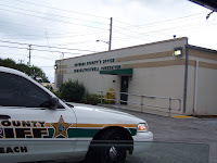
The area to the south is residential, and a sheriff’s substation is located on the corner of 18th Avenue.

Once past Powerline Road (2100 block), you are in NIMBY land, where there are two strip joints and three prisons within blocks of MLK Blvd.

MLK Blvd ends at NW 31 Avenue, where there is a Florida Turnpike entrance.

Length:

Approximately 3 miles

·000 Block (Dixie Highway) to 3100 Block West.

Category:

Residential Neighborhood (houses fronting MLK Blvd) = 0%

Commercial Corridor: Main Street = 0%

Commercial Corridor: Mom & Pop Shops = 20%

·Blighted and Ignored = 30%

·Blighted but Not Ignored = 30%

·Gentrification Failing = 0%

·Gentrification Succeeding = 10%

·Viable with Room to Improve = 20%

·Vibrant and Car Friendly = 10%

· Vibrant and Pedestrian Friendly = 0%

Industrial Corridor = 80%

·Blighted and Ignored = 50%

·Blighted but Not Ignored = 30%

· Gentrification Failing = 0%

·Gentrification Succeeding = 10%

·Viable with Room to Improve = 10%

· Vibrant and Car Friendly = 0%

·Vibrant and Pedestrian Friendly = 0%

Community Assets:

1) The E. Pat Larkins Community Center at 520 MLK Blvd. It is a brand new facility built in a relatively safe area. It seemed well staffed with a broad variety of programs for all age groups. (http://www.mypompanobeach.org)

2)Churches: Along the length of the boulevard there were three significantly large and well maintained churches, and perhaps a half-dozen small “store-front” churches.

3)National Chain Grocery or Department Stores: None were encountered.

4) Brand Name Franchised Restaurants: At the far western end, where the ramp to the turnpike is located and you are within a block of Coconut Creek, there is a Wendy's Restaurant.

5)Other National Franchises: None, not even an auto parts franchise.

NIMBY Items Encountered:

1)Three prison facilities (within 3 blocks)

2)Two strip clubs

3)Two major rail corridors

4)Three major overpasses (only two with access)

Indexing for This Topic: